- Home
- Who We Are
- Products
-
Brands
-
Products by Measure
- Vibration Analyzers
- Peristaltic Pumps
- Airflow
- CO Carbon Monoxide
- Geiger counters
- Destiladores
- Spectrophotometry
- Sterilization
- Fluorescence
- GEOTECHNICS
- Soil Moisture
- Leaf area index
- Rain Gauge
- Meteorology
- Water Level
- O2 Oxygen
- pH
- Differential Pressure
- Radiation
- Salinity/Conductivity
- Telemetry
- Air Speed
- Relative Humidity
- Veterinary
- FUEL CELL HARDWARE
- Network Analyzers
- Calibrators
- WATER FLOW
- Color / Colorimeter
- Particle Counters
- Wind Direction
- Spectrometry
- Evapotranspiration
- Photosynthesis
- Cracks in Buildings
- Pipes Inspection
- Quantum Light
- Movement & GPS
- Diesel Level
- Oxígeno Disuelto DO
- Atmospheric Pressure
- Radon
- Sap/Sap Flow
- Temperature
- AIR QUALITY
- Ammonia
- Chlorophyll
- Conductivity in Soil
- Dendrometers
- Electrochemistry
- Spectroradiometry
- Pharmacy & Medicine
- GAS (ANALYZERS)
- Leaf Wetness
- Idc (DC Current)
- KW & KW/H
- PAR Light
- Nitrate
- Occupation and Time
- Particle Meters
- Soil Water Potential
- Pulses
- Flavor/Taste/Acidity
- Sodium
- Turbidity
- VOC
ZondRes2d Professional software for interpreting 2D electrical tomography data
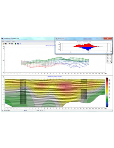
Two-dimensional interpretation of electrical tomography data by resistivity and induced polarization
ZondRes2d Professional software for interpreting 2D electrical tomography data
I accept privacy policy rules
General
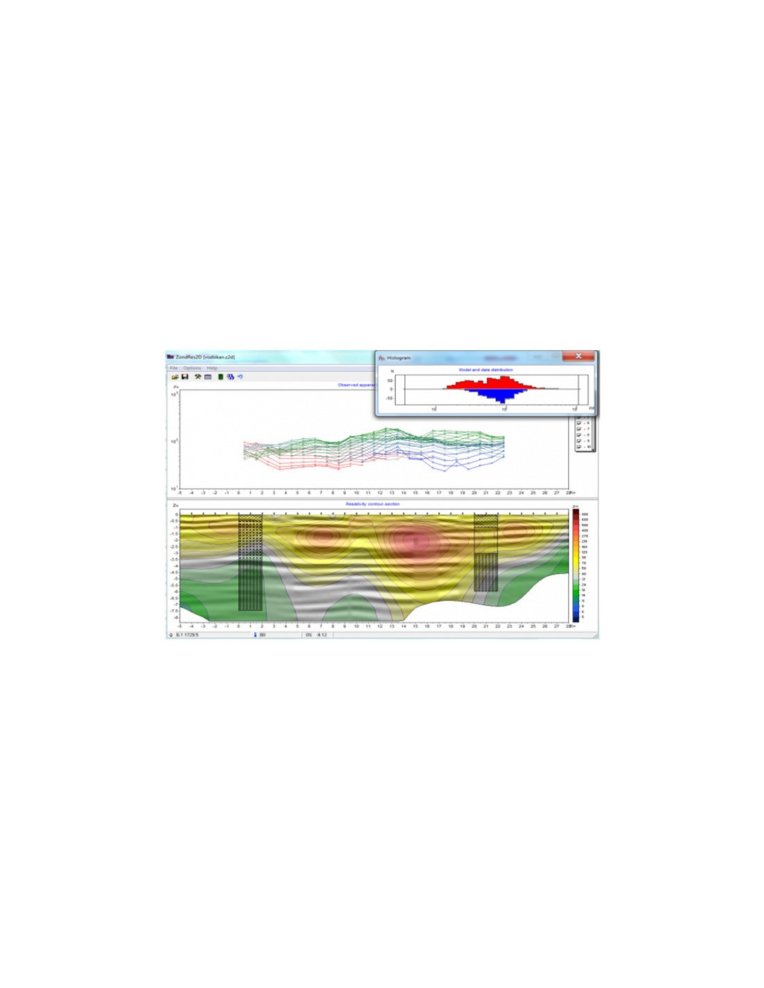
ZondRes2d is software for interpreting 2D electrical tomography data using resistivity and induced polarization.
It is designed to work with geophysical datasets focused on the analysis and interpretation of two-dimensional electrical tomography surveys.
- 2D electrical tomography data interpretation
- Supports resistivity datasets
- Supports induced polarization datasets
- Specialized software for geophysical applications
Specifications
- Product type: Software
- Name: ZondRes2d
- Main function: interpretation of 2D electrical tomography data
- Supported technologies: resistivity and induced polarization
- Manufacturer: MAE SRL
Main Features
This software provides an advanced environment for processing, modelling and inversion of geophysical data, especially for electrical resistivity, induced polarization and complementary geophysical methods.
Key Functions
- Supports any electrode arrays or combinations, including arbitrary electrode spacings and positions.
- Allows different arrays with different numbers of electrodes to be used on the same site.
- Supports measurements at the water surface and on the water bottom, as well as borehole, cross-borehole and mixed survey systems.
- Four methods for defining topography, with real-time editing.
- Two induced polarization inversion methods:
- Standard static IP inversion.
- Full waveform IP inversion for Cole-Cole parameters in the time and frequency domains.
- Approximate and full-solution calculation options.
- Script recording for automatic multi-file processing.
- Working buffer for up to 5 models.
- Resistivity and IP data quality control, including denoising and data editing tools.
- Advanced tools for mathematical modelling of geoelectrical sections:
- Standard “bitmap-style” mesh.
- Arbitrary layered models.
- Polygonal-style models.
- Additional tools for gravity, magnetic and self-potential forward modelling and joint inversion.
- Several resistivity and IP inversion algorithms:
- Smooth.
- Focusing.
- Robust.
- Block-based.
- Reference model definition for inversion.
- Noise component suppression during inversion using robust reweighting.
- Suppression of P/C static shifts during inversion.
- Support for anomalous MAN and AMNA arrays using the true anomalies method.
- Definition of limits for model parameters.
- Integration of a priori geological boundaries and borehole data into the inversion process.
- Weight assignment for data records and advanced measurement editing.
- Quality assessment of inversion results based on sensitivity matrix analysis.
- Calculation of sensitivity, quality and DOI index.
- Model edge cutting by angle or sensitivity level.
- Multiple visualization options for data, models and a priori information.
- Ability to use a semi-transparent background for resistivity sections, such as geological or seismic sections.
- 3D visualization of geoelectrical sections along arbitrary profile systems.
- Generation of parameter map slices at different depths.
- Geological section editor and borehole column editor, including titled boreholes.
- 2D joint inversion with magnetotelluric, refraction seismic and TDEM data.
- MMR method support.
- Export to multiple formats:
- Bitmap images.
- Vector graphics.
- Excel.
- Surfer.
- AutoCAD.
- Scale settings for exported images.
- Image printing and technical report generation.